
ここからコンテンツです。
A statistical model for ensuring children can move around safely
Efficient identification of potential traffic accident risk locationsKojiro Matsuo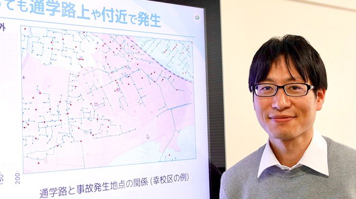
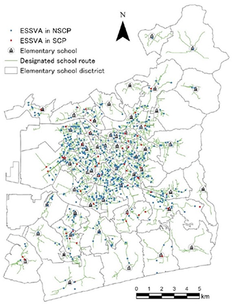
A research team led by Kojiro Matsuo, an associate professor at the Department of Architecture and Civil Engineering within the Toyohashi University of Technology, and Kosuke Miyazaki, a professor at the Department of Civil Engineering within the National Institute of Technology – Kagawa College, has established an efficient means of identifying high risk road intersections in terms of accidents involving children. A statistical model is used to prevent accidents by identifying locations at high potential risk of accidents, even where none have occurred, based on a variety of factors. These include unique geo-informatized data for school commuting routes and school walking groups held by Toyohashi City, road traffic big data, past accident data, intersection structures and land-use.
Children in Japan often wander around by themselves from around seven years old (1st and 2nd grades of elementary school). Although this is somewhat unusual from an international perspective, in Japan it is considered to be an essential part of the children’s health and development. In order to safeguard this tradition, improving the safety of children’s travel is therefore a requirement.
Achieving this however, is easier said than done, due to the difficulties involved in identifying the zones and locations where traffic safety measures should be implemented. While the number of locations used by child pedestrians is enormous, traffic incidents involving children are rare, making data computation challenging. The goal is to evaluate quantitatively the potential risk at each location, while efficiently identifying places where additional measures are required.
Accordingly, the research team established a method using a statistical model to efficiently identify potentially dangerous intersections in terms of traffic accidents involving children.
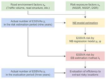
Associate Prof. Matsuo, as lead researcher, explained, “This statistical model has two main characteristics. The first uses Empirical Bayesian estimation to combine the average impact of environmental road traffic conditions, such as traffic volume, intersection structure, and land usage status – as obtained from road traffic big data – balanced appropriately with past accident data. The second is to incorporate data on how much children travel with road traffic conditions using unique geo-informatized data on school commuting routes and walking groups held by Toyohashi City.
Ultimately, the fact that it identified seven or more potentially dangerous spots proved that it is more efficient and effective at such identification than methods based simply on past accident data. Furthermore, we validated the current policy of "implementing traffic safety measures primarily on school commuting routes," because Japanese children tend to use familiar routes not only on their way to and from school, but also during any daily outings, even while accidents along these routes are increasing."
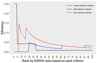
Blue line: Identification based on Negative Binomial Regression Model
Red line: Identification based on the Empirical Bayes estimation established through this research
Associate Prof. Matsuo added, "This research would not have been possible without the geo-informatized data on school commuting routes and walking groups made available by Toyohashi City. I had been acting as an advisor to Toyohashi City on safety measures for school commuting routes, and as an administrative initiative, I planned the efficient management and utilization of data on school commuting routes and walking groups in 2015. After proposing the use of geo-informatized data and the data structure, this was officially adopted from 2016. Back in those days, I never imagined that this data would become useful for my research, but I am delighted that the measures implemented six years ago are still being used. I hope that in the future, other municipalities will also promote the use of geo-informatized data with school commuting routes."
Through this research, we devised a way to identify potentially dangerous locations based on objective information acquired from various data. However, real-world traffic is complicated, and data represents only a part of it. The research team would like to promote research into how best to efficiently combine subjective information held by the public, such as close calls, with objective information.
Reference
Kojiro Matsuo, Kosuke Miyazaki, Nao Sugiki (2022). A Method for Locational Risk Estimation of Vehicle–Children Accidents Considering Children’s Travel Purposes. International Journal of Environmental Research and Public Health.
https://doi.org/10.3390/ijerph192114123
子供の安全で健やかな移動を守るための統計モデル
潜在的な交通事故危険地点を効率的に抽出松尾 幸二郎
豊橋技術科学大学建築・都市システム学系 松尾 幸二郎准教授らと香川高等専門学校建設環境工学科 宮崎 耕輔教授の研究チームは、子供が巻き込まれる交通事故の潜在的な危険交差点を効率的に抽出するための手法を構築しました。過去の事故データ、自動車交通ビッグデータ、交差点構造や土地利用等のデータに加えて、豊橋市が独自で地理情報化している通学路・通学班データを活用した統計モデルにより、まだ事故が起きていなくても、今後起こる可能性の高い地点の抽出を行い、未然防止対策に役立てることができます。
日本の子供は7歳(小学1~2年生)頃から、子供達だけで外出することがしばしばあります。これは国際的に見ると貴重な状況であり、また子供の健康や発達にも寄与していると考えられています。従って、この状況を今後も継続していくことは大変重要であり、そのためには、子供の移動における安全性の向上が必須要件です。子供の移動の安全性を向上させるための交通安全マネジメントにおいては、交通安全対策を実施すべき地区や地点を適切に抽出することが必要ですが、交通事故自体が稀な現象であるとともに、子供が通る地点は非常に多くあることから、抽出は決して容易ではありません。各地点の潜在的な危険性を定量的に評価し、対策すべき箇所を効率的に抽出することが求められます。
そこで、研究チームは、統計モデルを用いて子供の交通事故の潜在的な危険交差点を効率的に抽出するための手法を構築しました。「本統計モデルの特徴は大きく2点あります。1つ目は、自動車交通ビッグデータから得られる交通量の多寡、交差点構造、土地利用状況といった道路交通環境条件が事故危険性に与える平均的な影響と、過去の事故発生状況を、経験ベイズ法を用いて適切なバランスで組み合わせている点です。2つ目は、豊橋市が独自で地理情報化している通学路・通学班データを用いて、子供の移動量の多寡を道路交通条件の中に組み込んでいる点です。
結果として、潜在的な危険地点を7地点以上抽出する場合には、過去の事故情報だけで抽出するよりも効率的かつ効果的に抽出することができることが示されました。また、日本の子供達は登下校中に限らず、普段の外出においても、慣れ親しんでいる通学路を通る傾向にあり、通学路上での事故が多くなっていることから、『通学路を中心とした交通安全対策を実施する』という現在の方針が間違っていないことも検証することができました。」と研究リーダーである松尾准教授は説明します。
さらに松尾准教授は「本研究は、豊橋市により地理情報化された通学路・通学班データが無ければ成しえませんでした。私は、以前から豊橋市の通学路安全対策アドバイザーを務めており、行政における取り組みとして、2015年に通学路・通学班データの効率的管理・活用を企図し、地理情報化とそのデータ構造を提案した結果、2016年から本格導入されました。当時は、このデータを自分の研究に用いることは全く考えていませんでしたが、6年前の取り組みが現在に活きていると思うと、感慨深いです。今後、他の自治体でも、通学路データの地理情報化や活用が進んでいくことを期待しています。」と述べています。
本研究では、様々なデータから得られる客観的な情報を基に、潜在的危険地点の抽出を行う手法を構築しました。しかしながら、現実の交通状況は複雑であり、データはその一部を切り取っているだけに過ぎません。研究チームは、今後、市民によるヒヤリハットといった主観的な情報を、客観的な情報とどのように効果的に組み合わせていくかについて、研究を進めていきたいと考えています。
Researcher Profile
| Name | Kojiro Matsuo |
|---|---|
| Affiliation | Department of Architecture and Civil Engineering |
| Title | Associate Professor |
| Fields of Research | Traffic Engineering / Infrastructure Planning |
| Graduated KOSEN | National Institute of Technology, Nagano College |
ここでコンテンツ終わりです。