
ここからコンテンツです。
Pick Up
Advanced vehicle probe data collection devices installed in Toyohashi City official vehicles identify potential pedestrian accident hazard spots
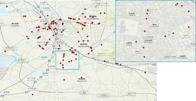
The Advanced Vehicle Probe Data Collection System (“a-probe”) accumulates real-time collision prevention warning data for pedestrians and vehicles in the cloud, along with the location and time of the driving vehicle, as well as speed sign data and other information captured from camera images. By analyzing this data and combining it with various other factors such as the number of lanes on the road, intersections, residential conditions around the road, and traffic volume, we can efficiently and accurately identify potential roadway hazard spots.
The installation of this “a-probe” on 50 Toyohashi City official vehicles was completed in March 2020, and the data has been accumulating daily since then.
The data analysis technology developed by Associate Professor Kojiro Matsuo at TUT has made it possible to not only identify pedestrian accident risk points, but also to create detailed maps of road speed restrictions. The City of Toyohashi will use this data analysis-based road-traffic safety management system to promote a safer city with the goal of zero traffic accidents. J21 Corporation based in Toyohashi Japan, the partner in charge of developing this “a-probe”, is leading the commercialization of the "Traffic Safety Management System with Advanced Probe Data" model.
Reference
豊橋市の公用車に搭載された先進車両プローブデータ収集デバイスが、潜在的な歩行者事故の危険箇所を特定する
先進車両プローブデータ収集装置("a-probe")は、歩行者や車両やとの衝突事故防止警報データを、運転中の車両の位置や時刻情報、さらにはカメラ映像から得た速度標識データや他の情報も合わせて、リアルタイムにクラウドに蓄積します。このデータを、道路の車線数や交差点、道路周辺の住宅状況、交通量などの様々な条件と組み合わせて分析することで、道路の潜在的な危険箇所を、効率的かつ正確に特定できます。
豊橋市の公用車50台へ、このa-probeの設置が2020年3月に完了し、その後毎日データが蓄積されています。
TUT松尾幸二郎准教授のデータ分析技術は、歩行者事故の危険箇所の推定を可能とすることに加えて、細かな道路にまで対応した速度規制マップの生成に成功するなどの成果を上げています。豊橋市は、この成果を活用した道路交通安全管理システムを行政に利用して、交通事故のない安全な街づくりを推進していきます。このa-probeの開発を担当するジャパントゥエンティワン株式会社(本社 豊橋)は、「先進プローブデータ活用型交通安全管理システム」モデルのビジネス事業化をリードしています。
ここでコンテンツ終わりです。