
ここからコンテンツです。
Understanding the Sea Close to Us
Grasping the sand movements of coasts, estuaries, and bay areas By Shigeru Kato
In Japan, with its very long coastline, coastal erosion has become a serious problem due to factors such as the decrease in the supply of sediment from land area as well as the interruption of sediment flow caused by structures. At the Department of Architecture and Civil Engineering at Toyohashi University of Technology Professor Kato and his team are conducting surveys and studies to ascertain changes in coastal topography and the movement of sand, with the goal of achieving appropriate sediment management in coastal areas.
Japan is a small island country surrounded by sea, but it has one of the longest coastlines in the world. The coastline is about 35,000 km, which is about 85% of the distance around the Earth (about 40,000 km). Every day, this extremely long coastline is exposed to high waves generated by low atmospheric pressure and storm surges due to typhoons, and the topography of the coastal area is constantly changing. The coastal environments we are so familiar with, such as sandy beaches and tidal flats, have up to now been maintained by sediment supply from the land carried by rivers and other sources.
However, not only is this supply drying up, but the development of coastal areas due to land expansion and the construction of coastal structures on landfills have also damaged the balance of sediment dynamics (movement of sand). This delicate balance depends upon the preservation of the thin layer of sediment in coastal areas. Serious coastal erosion is occurring across the country as a result.
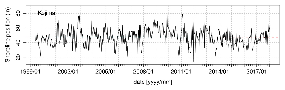
Toyohashi University of Technology is located in a place surrounded by rich marine environments such as the open sea and bays as well as freshwater rivers and lakes. Our Coastal Engineering Laboratory has been actively engaged in monitoring the changes of such areas. For example, we have been monitoring in cross-section profiles and shoreline positions of sandy beaches, analyzing the chemical element characteristics of beach sand and investigating sediment transport in tidal flats in order to get an understanding of sediment dynamics. This work is carried out primarily in the coastal areas of the open sea, bays, and estuaries. We are continuing the work of monitoring the sand beach sectional topography and shoreline positions of the Omotehama coast, which was started by Prof. Aoki in 1999.
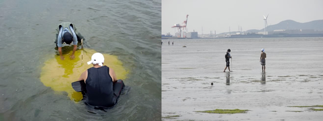
To date we have accumulated the data over about 18 years (Fig.1). The data is also used as basic data for the decisions regarding shoreline management under the Aichi Prefecture’s coastal conservation plan. By analyzing the chemical element properties of beach sand using fluorescent X-ray analysis, we have determined that the content of elements such as Fe (iron), Mn (manganese), and Ti (titanium), all of which are always detected, can be used as an index to judge erosion / deposition tendencies of beaches, elevation above sea level (height) of sandy beaches, and size of sand grain. We are also conducting surveys that locally track the movements of the sand by injecting color sand (artificially-colored sand) into the tidal flat and measuring the topography of the tidal flats (Fig.2). Recently, we have also been attempting morphometry of tidal flats using UAVs (drones) (Fig. 3), and we are also conducting surveys and research on monitoring and conservation of the nearshore environment.
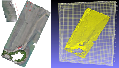
(Survey area: Higashihazu-cho, Nishio-shi, Aichi prefecture),
Composite photograph of the full view of the tidal flat (left),
Three-dimensional shape of the constructed tidal flat (right).
It is important to properly ascertain the abundance of sediment (Stock) and its movement (Flow) in the coastal areas in order to develop countermeasures and solutions to the problem of coastal erosion. The purpose of our coast survey and topography monitoring by UAVs is to grasp the actual situation by actually investigating the site. In addition, our goal with the chemical element analysis is to establish it as a new tool for understanding sediment dynamics in the coastal regions. We are conducting these surveys and research while experiencing the richness, bounty, and constantly changing face of these natural sites first hand.
Part of this activity was supported by the following funds.
- Grants-in-Aid for Scientific Research (Challenging sprout research, assignment number 24656294)
- Mitsui & Co. Environment Fund (Research grant for 2013, Representative: Aichi Fisheries Research Institute)
身近な海を調べる
海岸や河口、内湾域での砂の移動を把握するBy 加藤 茂
非常に長い海岸線を持つ日本では、陸域からの土砂供給量の減少や構造物による土砂移動の連続性の遮断により、各地で海岸侵食が深刻な問題となっています。豊橋技術科学大学建築・都市システム学系の加藤茂教授の研究グループでは、沿岸域での適切な土砂管理を実現するために必要な海岸地形の変化や土砂の移動状況を把握する調査・研究を実施しています。
日本は海に囲まれた小さな島国ですが、その海岸線は約35,000kmであり、地球一周の長さ(約40,000km)の約85%にも及ぶ世界でも有数の長い海岸線を有しています。この非常に長い海岸線は、低気圧等によって発生する高波や台風による高潮などに日々さらされており、沿岸域の地形は絶え間なく変化しています。砂浜や干潟などの我々の生活に身近な海岸の環境は、河川等による陸域からの土砂供給によって維持されてきました。
しかし、近年は陸域からの土砂供給が減ったことに加えて、埋め立てに陸地の拡大や海岸構造物の建設等による沿岸部の開発により、沿岸域に存在する僅かな土砂で保たれていた漂砂バランス(土砂の移動)が壊してしまい、その結果として深刻な海岸侵食が各地で発生しています。
豊橋技術科学大学は、周囲を外洋、内湾、河川、湖といった豊かな水環境に囲まれた位置に立地しています。我々の海岸工学研究室では、主に外洋や内湾の沿岸域や河口部での土砂動態を把握することを目的として、砂浜の断面形状や汀線位置の変化のモニタリング、海浜砂の化学元素特性の把握、干潟での土砂移動調査などに取り組んできました。前任者の青木教授が1999年に開始した表浜海岸での砂浜断面地形と汀線位置のモニタリングは継続中で、現時点で約18年にわたるデータを蓄積しています(Fig.1)。このデータは愛知県の海岸保全計画における管理汀線決定の基礎資料にもされています。蛍光X線分析を用いた海浜砂の化学元素特性の把握では、常に検出されるFe(鉄)やMn(マンガン)、Ti(チタン)などの元素含有量を、海浜の侵食/堆積傾向や砂浜の標高(高さ)、砂の粒径(砂粒の大きさ)を判定する指標として利用可能であることを明らかにしてきました。また、干潟にカラーサンド(人工的に色を付けた砂)を投入し、その砂の移動を現地で追跡する調査を行ったり、干潟の地形計測なども実施しています(Fig.2)。最近は、UAV(通称、ドローン)を用いた干潟地形計測にも挑戦しており(Fig.3)、沿岸環境のモニタリングとその保全について調査・研究を行っています。
海岸侵食問題への対策やその解決には、沿岸域における土砂の存在量(Stock)とその移動量(Flow)を適切に把握することが重要です。我々の実施している海岸測量やUAVによる地形モニタリングは、実際に現地を調査することでその実態を把握することを目的としており、化学元素分析は沿岸域での土砂動態を把握するための新たなツールとして確立することを目指しています。実際に現地に足を運び、現地を肌で感じることで、自然の豊かさや恩恵、変化を体感しながら、これらの調査、研究を実施しています。
本研究の一部は以下の助成を受けて実施いたしました。
- 科学研究費補助金(挑戦的萌芽研究、課題番号24656294)
- 三井物産環境基金(2013年度研究助成、代表:愛知県水産試験場)
Researcher Profile
| Name | Shigeru Kato |
|---|---|
| Affiliation | Department of Architecture and Civil Engineering |
| Title | Professor |
| Fields of Research | Coastal Engineering / Coastal Disaster Mitigation |
ここでコンテンツ終わりです。