
ここからコンテンツです。
Making buildings safer by preemptively visualizing earthquake damage
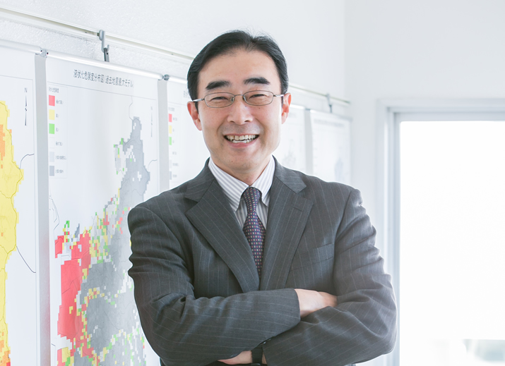
Taiki Saito
The series of earthquakes which hit the area in and around Kumamoto Prefecture in April 2016 are still fresh in our memory. Recorded twice at a seismic intensity of 7 , the shocks killed or injured more than 2,000 people. These casualties, for the most part, were attributed to collapsed buildings, as was the case in the Great Hanshin-Awaji Earthquake in 1995. In spite of the scale of the destruction, effective countermeasures have still to be sufficiently implemented. To avoid such tragedies from happening again, Professor Taiki Saito has been conducting research to visualize how earthquakes shake and damage buildings and hopes to apply his research outcomes to disaster prevention.
Interview and report by Madoka Tainaka
Development of Software to Visualize Shaking and Damage of Buildings
According to the Cabinet Office’s report of November 14, 2016, the earthquakes that hit Kumamoto Prefecture severely damaged over 180,000 houses, of which over 8,000 were completely destroyed . The Kumamoto eathquakes were far from being a rare occurrence. In the following year a series of destructive quakes struck around the world, such as in Italy and New Zealand, as well as closer to home, in the central part of Tottori Prefecture in October. In all of these examples earthquake-induced building collapse had a destructive impact on life and property.. Given this critical situation, the critical importance of Professor Saito’s efforts to make buildings safer by preemptively visualizing earthquake damage becomes clear.
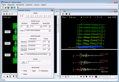
One of the innovative accomplishments of his research is STructural Earthquake Response Analysis 3D: STERA_3D, a software tool which allows for a seismic analysis of buildings with various structures, including reinforced concrete. Professor Saito explained the aim of this software development as follows: “If you can understand in what way your house is likely to sway and collapse in the event of an earthquake, you will be better able to prepare for it beforehand. In reality, however, it is difficult to make such predictions unless you are a structural expert. That’s why we have developed a software application that, by simply entering data such as column or beam size taken from the building’s blueprints, allows you to see an animated simulation of earthquake tremors and structural vulnerability.”
The Japanese and English versions of this software are available to download for free from Professor Saito’s laboratory website. Another software tool called STructural Earthquake Response Analysis FEM: STERA_FEM, a software for visualizing the stress placed on a building’s planar structural members such as walls, is also available from the same website. Professor Saito says these tools allow you to intuitively understand the risk factors of a building by showing damage-prone spots in red. They are already in use in a wide variety of environments, including research and education.
(http://www.rc.ace.tut.ac.jp/saito/software-e.html)
Using Tools for Building Analysis of Post-Earthquake Disaster Management Facilities
We cannot exactly tell when or where an earthquake will strike. Toyohashi City, the home of Toyohashi University of Technology, situated above the Nankai Trough, is estimated to have a 70% chance of experiencing an earthquake of magnitude 6 to 7 on the seismic intensity scale within the next 30 years. A sense of alarm about the impending earthquake has motivated Professor Saito to work on his research.
“One of the most crucial issues in times of disaster is securing the use of disaster management facilities such as city halls, hospitals and fire stations. However, various disaster management facilities, such as Uto City Hall, were themselves damaged by the earthquakes in Kumamoto Prefecture. This factor significantly hindered the city’s evacuation and recovery operations. The problem is that you cannot tell the risk of collapse just by looking at the building from the outside,” says Professor Saito.
He further explains that a major vertical crack, for example, between two buildings of an apartment complex might appear to be hazardous to the untrained eye, but it is fairly safe as the two buildings are structurally separate. On the contrary, he adds, cross-shaped or horizontal cracks in a column are far greater hazards even when no major damage is apparent.
“To address this issue, we ran seismic simulations on the east and the west buildings of Toyohashi City Hall using my analysis tools with the data of the ground motion waveform prediction for the Nankai Trough earthquake provided by the Ministry of Land, Infrastructure, Transport and Tourism. As a result, we have found that the buildings have sufficient earthquake resistance. It turned out, however, that the west building is at risk of damage such as cracked walls and collapsed ceiling panels. Over in the east building, it was determined that in the case of a strong magnitude 7 quake, people would be unable to stay on their feet, and cabinets not secured to the floors or walls would fall over.
We don’t know for certain what would really happen since the results are only simulations based on the drawings. We might be repeatedly hit by earthquakes of an unexpected scale, just as the people in Kumamoto have recently experienced. Currently we are in the initial stages of monitoring buildings to assess whether it is safe to continue using the buildings in the event of actual earthquakes,” says Professor Saito.
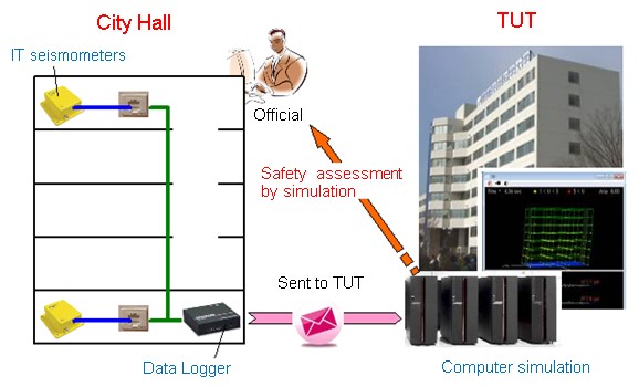
More specifically, his concept involves the following. His research team installed three IT strong-motion seismometers in the city hall to continuously monitor vibrations. Every five minutes, the vibration data obtained by the seismometers are sent to the computers in Toyohashi University of Technology via the Internet for the analysis tools to run simulations in the cloud.
“If an earthquake strikes, we hope to be able to use the results of the simulations to assess whether it is safe to continue using the buildings. We are planning to implement more measures against earthquakes, such as having additional monitoring locations including fire stations and evacuation facilities, and installing a dedicated line for disaster prevention. Accumulating real-time data in the cloud can also improve the accuracy of the simulations.”
Sharing Research Outcomes to Raise Awareness of Disaster Prevention
Professor Saito has also developed software that shows an animated simulation of earthquake damage inside houses such as that caused by falling furniture. This software application works on smartphones and makes it easy to run simulations, with a flexibly adjustable furniture layout and an easily configurable restitution coefficient and friction coefficient . The existence of such a tool greatly contributes to raising awareness of disaster prevention not only among researchers and experts, but also the general public.
In addition to his work as a researcher, he also conducts analysis of buildings in Toyohashi City and writes informative books for the general public. Through such activities, he has once again realized the power of his analysis software.
“By seeing things in animation, people can identify them as immediate concerns, not just as abstract knowledge. It is not enough to know that an earthquake may strike, rather it is very important to imagine in detail what may actually happen beforehand. I should also mention this. A common mistake people make is to try to hold their furniture against the wall to prevent it from falling during an earthquake, but this only has a minimal effect and can be very dangerous. By widely sharing such insights which I have derived from my research, I hope to contribute to society by raising public awareness about disaster prevention.”
Professor Saito’s vision for the future is that he would like to work on more sophisticated analysis that incorporates topographic and geotechnical information.
“We are currently studying a collapsed apartment that stood at the edge of a cliff before the earthquakes in Kumamoto. All the surrounding buildings survived the quakes but only this apartment collapsed. The shaking of buildings greatly varies depending on the conditions of the ground and topography. It is no easy task to add geotechnical models to simulations, but we hope to provide more accurate analysis software by translating geotechnical characteristics into numerical data.”
It is not easy to prepare for an earthquake when we do not know when it will strike, but we can at least save some lives by implementing seismic safety measures on buildings and furniture. I truly hope that Professor Saito’s research will lead to the implementation of anti-earthquake measures on more buildings.
Reporter's Note
When he was a student of Tohoku University, Professor Saito worked on an analysis of the earthquake that struck off the coast of Miyagi Prefecture in 1978. The output of simulations in those days was in the form of numerical data only and it was difficult to intuitively understand the extent of the damage. The frustration he felt back then has driven him to achieve his current research accomplishments.
“I actually used my analysis software before I bought an apartment,” says Professor Saito. Even if it complies with the Building Standards Act, you cannot tell the level of the actual aseismic performance just from its appearance. His wife really liked one apartment on the top floor with a wide balcony, but as a result of the analysis, the apartment turned out to be structurally vulnerable. Eventually, “My wife was convinced and we bought a different apartment,” says Professor Saito with a laugh. It seems that the power of visualization was required to convince his wife.
地震による建物被害の「見える化」を防災対策支援へ役立てる
まだ記憶に新しいが、2016年4月に発生した熊本県地震では、震度7の地震を2度も観測し、2000名を超える死傷者を出した。その死傷の原因の多くは、建物の倒壊によるものである。建物倒壊は、1995年の阪神淡路大震災でも大きな被害をもたらしたが、対策はまだ十分に取られてないない。こうした悲劇を繰り返さないために、齊藤大樹教授が取り組むのは、地震による建物の揺れや被害を可視化し、防災支援に役立てる研究である。
建物の揺れや被害が見えるソフトウェアの開発
熊本地震では、住宅の全壊は8000棟以上に上り、半壊や一部破損を合わせると18万棟以上が被害を受けたとされる(2016年11月14日現在、内閣府資料より)。その後も10月の鳥取県中部地震に続き、イタリアやニュージランドでも地震による建物の倒壊による被害が相次いでおり、齊藤教授が手がける建物被害の可視化を防災支援に役立てる研究は、まさにいま、社会が必要とする最重要課題への取り組みと言える。
なかでも齊藤教授の研究の画期的な成果の一つが、鉄筋コンクリート造をはじめとする各種構造の建物の立体骨組みに対応した、解析ソフト「建物の立体地震応答プログラムSTERA_3D」の開発である。齊藤教授は、開発の目的を次のように説明する。
「自分が住んでいる家が地震のときにどう揺れ、どう壊れるのかがわかれば、事前に対策を立てることができます。しかし実際には、構造の専門家でもない限り、あらかじめ知るのは難しいですよね。そこで、設計図をもとに、梁や柱などの数値を入力するだけで簡単にシミュレーションができ、アニメーションで地震の揺れや建物の弱点を表すアプリケーションを開発しました」
このソフトは、フリーソフトとして日本語版と英語版が公開されており、齊藤教授の研究室のホームページから誰でも自由にダウンロードできる。同時に、建物の壁など平面部材にかかる力(応力)を可視化するソフト「有限要素解析ソフトウェアSTERA_FEM」も公開。破壊される可能性がある箇所を赤色で示すなど、直感的に建物の状況が理解できるツールとして、すでに研究や教育など、さまざまな場面で活用されているという。
(http://www.rc.ace.tut.ac.jp/saito/software-e.html)
地震後の防災拠点の建物診断にも活用
地震はいつどこで起こるかわからないが、豊橋技科大が立地する豊橋市は、30年以内に70%の確率で起こると予想される南海トラフ地震で、震度6強から7の激しい揺れが想定される地域である。その危機感が、齊藤教授を研究に駆り立てる原動力にもなっているという。
「なかでも被災時の大きな課題が、市役所や病院、消防署などの防災拠点の機能を確保する点にあります。実際に熊本地震では、宇土市役所をはじめとする複数の防災拠点が被害を受け、避難や復旧の大きな障壁となりました。問題となるのは、建物の倒壊の危険性は外側から見ただけではわからない点にあります」と、齊藤教授は言う。
例えば、マンションの棟と棟の間に生じた縦の大きな亀裂は、素人目にはいかにも危険に見えるが、実際にはそれぞれ構造的に切れているため問題ない。一方、一見、大きな損壊はないのに、柱にバツ状や横に亀裂が入っているほうがはるかに危ないという。
「その対策として、豊橋市役所の西棟、東棟について、国土交通省による南海トラフ地震の予測地震動波形を使い、それぞれ解析ツールでシミュレーションを行いました。その結果、耐震性は確保されていることがわかりました。ただし、西棟では壁のひび割れや天井パネルの落下の危険性が、東棟では震度7では激しい揺れで立っていられないこと、固定していないラックなどは転倒することがわかりました。
ただ、元となるのはあくまでも図面からの情報であって、実際の状況はわかりません。熊本地震のように、想定外の揺れに何度も見舞われないとも限りません。そこで、実際に地震が起きたとき、その建物を使い続けられるかどうかを判断するために、建物のモニタリングを始めたところです」と齊藤教授は言う。
具体的には、市役所にIT強震計を3台設置し、常時、振動をモニタリングする。IT強震計から得た振動情報は、インターネット経由で5分ごとに豊橋技科大のコンピュータに送られ、クラウド上で解析ツールを用いてシミュレーションを行うという構想だ。
「万一、地震が起こったら、シミュレーション結果をもとに、建物を使い続けられるかどうかの判断に役立てたいと考えています。さらに、モニタリングを消防署や避難所にも拡大して、防災のための専用回線を設けるなど、対策を強化していく予定です。さらに、リアルタイムデータをクラウド上に蓄積することで、シミュレーションの精度向上にも役立てたいと考えています」
研究の成果を広め、防災意識を高めたい
さらに齊藤教授は、地震による家具の転倒など、室内被害の様子をアニメーションで示すシミュレーションソフトの開発も手がける。こちらは、スマートフォンでも動くアプリで、家具のレイアウトを自在に変えられるほか、シミュレーションに必要な反発係数や摩擦係数なども簡単に設定できることから、研究者や専門家だけでなく、一般市民の防災意識向上にも寄与している。
そのほか研究者としての活動の傍ら、豊橋市内の建物の解析や、一般向けの啓蒙書の執筆なども手がける。そうした活動の中で、改めて自身の解析ソフトの威力を感じているという。
「アニメーションで見せることで、単なる耳学問ではなく、皆が我が身のこととして認識するようになるんですね。やはり事前に知識として知るだけでなく、想像力を養っておくことは非常に重要だと思います。ちなみに、地震のときに家具を倒れないように押さえる人がいますが、ほとんど力は伝わらないし大変危険なんですよ。このように私が研究を通じて得た知見をより多くの人に伝えることで、市民の防災意識を高め、社会に貢献していきたいですね」
今後はさらに地形や地盤を取り入れた、より高精度の解析にも取り組みたいと、齊藤教授は展望を語る。
「熊本地震で、周囲の建物は壊れていないのに、崖のヘリに建っているマンションだけが壊れたというので、調査をしています。地盤や地形によって、揺れ方は大きく違ってきます。地盤のモデルをシミュレーションに加えるのは容易ではありませんが、地盤の特性を数値化するなどして、より精度の高い解析ソフトを提供したいと思っています」
いつ来るかわからない地震に備えるのは容易ではないが、少なくとも建物や家具対策で救われる命が多数ある。齊藤教授の研究がより多くの建物の対策へとつながることを切に願う。
(取材・文=田井中麻都佳)
取材後記
学生時代、在籍した東北大学で、1978年に起きた宮城沖地震の解析を手がけたという齊藤教授。当時のシミュレーションの出力は数値データのみで、被害状況を直感的に掴むのは難しかった。そのときのもどしかしい思いが、今の研究成果につながっているという。
「実は、私がマンションを購入する際にも、自分の解析ソフトを活用したんですよ」と、齊藤教授。建築基準法を遵守していても、耐震の程度は見た目では判断できない。奥様がとても気に入ったあるマンションのベランダの広い最上階の部屋は、解析の結果、構造上、弱いことが判明。結局、「妻も納得してくれて、別のマンションを購入しました」と齊藤教授は笑う。奥様を説得できたのも、見える化によるところが大きかったに違いない。
Researcher Profile
Dr. Taiki Saito received a PhD. degree in engineering from Tohoku University, Sendai, Japan, in 1990.
Since receiving his PhD, he has been engaged in earthquake disaster engineering research as a research associate in Tohoku University, a senior research engineer in the Department of Structural Engineering of the Ministry of Construction’s Building Research Institute, and a Chief Research Engineer in the International Institute of Seismology and Earthquake Engineering, Building Research Institute. Since 2012, he has been a member of the Faculty of Engineering, Toyohashi University of Technology. He is currently working as a professor in the Department of Architecture and Civil Engineering and a director in the Research Center for Collaborative Area Risk Management (CARM) in Toyohashi University of Technology.
Reporter Profile

Madoka Tainaka is a freelance editor, writer and interpreter. She graduated in Law from Chuo University, Japan. She served as a chief editor of “Nature Interface” magazine, a committee for the promotion of Information and Science Technology at MEXT (Ministry of Education, Culture, Sports, Science and Technology).
ここでコンテンツ終わりです。